
Sheridan, Wyoming, USA – November 03, 2026
So, you’re on the hunt for the best industrial drone in China – it’s not just about comparing flight times or camera specs, believe me. A solid shortlist actually matches the aircraft to what you’re using it for: maybe you’re surveying a construction site, checking power lines, mapping out farmland, or hauling sensors around a factory. Each of those missions has its own set of demands – think payload, battery life, how it handles bad weather, navigation, and the kind of support you’ll get. And here’s the thing – the little details matter more than you’d think. Like, if that camera mount is a pain to swap out, your crew might waste a chunk of their day on it.So, when you’re looking at the Chinese market, you’ve got DJI, Autel, and JOUAV – all big names. They’ve got everything from small multirotors to those longer-endurance rigs. But here’s the thing: don’t just trust the specs you find online, because a lot of that info is outdated. You really need to check the manufacturer’s current docs – that’s the only way to be sure. And when you’re comparing, think about payload capacity, practical flight time, obstacle sensing, mapping workflow, battery logistics, repair access, and training needs. And don’t get too caught up in that long-range number – honestly, it doesn’t tell you much about how well it’ll perform on a repeatable inspection. Looks great on paper, but you know how that goes. You know, fieldwork isn’t exactly like a tidy lab experiment. It’s messier, honestly—things don’t always go as planned, and you just have to roll with it.So, let’s talk about what really sets the top options apart, what jobs they’re actually good for, and what you should double-check before you make a decision. I’m not going to pretend there’s one perfect pick for every crew out there—that’s just not how it works. The conditions on your site and the skills of your team can flip the whole thing on its head. And don’t even get me started on the published specs—they’re all over the place depending on payload, temperature, and how you fly the thing. So, do yourself a favor: confirm what you actually need and ask for a demo with the real gear you’d be using. This comparison is meant to be practical, not a sales pitch. Yeah, some trade-offs are just plain awkward, and you’d better pay attention to them.
 How Industrial UAVs Are Defined and Classified in China
In China, “industrial UAV” usually describes an unmanned aircraft used for professional work, rather than a single technical class. Typical tasks include surveying land, inspecting power lines, monitoring crops, and mapping construction sites. A camera-equipped aircraft above a field and a long-range fixed-wing mapper may both fit the term. Their jobs differ. So do their operating needs.
Classification can be considered in several ways. Civil aviation rules may group aircraft by weight and operating characteristics, while engineers often classify them by design: multirotor, fixed-wing, or vertical-takeoff hybrid. Buyers also sort them by mission, such as inspection or precision spraying. These categories overlap; a design label alone does not establish what an aircraft can safely do. The boundary is not always tidy. Payload capacity, flight time, wind tolerance, sensor quality, and maintenance access matter in real work. A specification sheet may look convincing, yet field conditions expose weak points. China’s applicable requirements can change, so users should confirm current category definitions and operating conditions with authoritative aviation sources.
Which Criteria Determine the Best Industrial UAVs?What Are the Best Industrial UAVs in China?Which Criteria Determine the Best Industrial UAVs?
The best industrial UAV is the one that performs a specific job reliably, not simply the aircraft with the longest advertised flight time. Grand View Research’s 2024 commercial drone report valued the global market at $30.02 billion in 2023 and projected 10.3% annual growth through 2030. That broad market estimate indicates expanding adoption, but it does not rank aircraft or guarantee performance at a particular worksite.
Compare usable payload and flight time together. A UAV carrying a thermal camera, for example, may stay airborne far less than an unloaded test suggests. Check weather resistance, operating temperature, obstacle sensing, and positioning accuracy. For mapping, repeatable routes and clear image quality matter; for inspections, stable hovering and dependable data links may matter more. Also assess battery availability, repair support, training, and data handling. These details are less exciting than flight range, yet often determine whether a fleet stays productive. No specification sheet fully captures field conditions.
Tips: Test the aircraft with the actual sensor and payload before purchase. Record flight time, image quality, and setup time on a representative site. Small test, useful evidence. Recheck the results in another season; wind and temperature can change them.
What Types of Industrial UAVs Are Made in China?
Chinese manufacturers make several types of industrial UAVs, each suited to different work. Multirotor aircraft use several vertical-lift propellers and can hover over a fixed point. They are commonly used for close-range inspections, site mapping, and carrying small sensors. A pilot can position one beside a roof edge or a power-line structure with fine control. That precision comes at a cost: flight time is usually shorter than with winged designs.
Fixed-wing UAVs generate lift as they move forward, making them suitable for surveying broad farmland, coastlines, or large construction sites. They can cover more ground per flight, but need room and planning for takeoff and landing. Hybrid VTOL models combine vertical takeoff with forward flight. They can launch from a compact clearing, then survey a longer route. The trade-off is greater mechanical complexity. Not always a simple choice.
Tethered UAVs receive power through a ground cable and can remain aloft for extended observation, such as monitoring a worksite. Their operating area is limited by the tether. These categories can overlap in real products, and labels alone do not prove performance. Buyers should compare tested flight time, payload capacity, wind tolerance, and sensor compatibility against the actual task. A published range may assume ideal conditions; that detail is easy to overlook.
How Do Leading Chinese UAV Platforms Compare?
Comparing industrial UAV platforms means matching airframe design to the worksite, not choosing the aircraft with the longest advertised range. Multirotors can hover over a leaking pipe or inspect a tower at close range, but their flight time usually limits coverage. Fixed-wing platforms cover long corridors efficiently, though they need clear launch and recovery areas. Hybrid vertical-takeoff designs bridge both roles, often with added mechanical complexity. Payload is only half.For buyers in China, compare usable payload, endurance under load, sensor compatibility, weather tolerance, and maintenance access. A thermal camera, mapping sensor, and spare battery all affect real mission time. CAAC’s 2023 Statistical Bulletin on Civil Aviation Development reported about 1.27 million registered civil UAVs and 23.11 million operating hours in China that year. That scale signals a mature operating environment, but does not prove any single platform suits every site. Weather changes everything.Ask vendors to demonstrate the same route with the intended payload, then record setup time, image quality, and battery reserve. Request service intervals and replacement-part availability, not just maximum-flight figures. One caveat: published specifications are rarely measured under identical conditions. A controlled field trial may reveal less flattering results, yet those results are more useful for procurement.
Which Industries Use Chinese Industrial UAVs?
Chinese industrial UAVs work across agriculture, energy, surveying, construction, and emergency response. In agriculture, operators use them to inspect crop health and apply treatments across large fields. A low pass reveals uneven growth. Power utilities use aerial cameras and thermal sensors to check lines, towers, and hard-to-reach equipment. Surveying crews map work sites, while construction teams compare aerial images with project plans.In emergencies, UAVs can provide overhead views of floodwater, damaged roads, or inaccessible terrain. Response work is uneven. Wind, rain, and weak communications can limit a flight, so crews still need ground checks and backup plans. That practical gap matters: a clear image does not always reveal the cause of a fault.The Civil Aviation Administration of China’s 2023 Statistical Bulletin on Civil Aviation Development reported 1.267 million registered civilian UAVs and 23.11 million flight hours nationwide. These figures show broad activity, but they do not separate industrial use from other applications. Buyers should therefore assess each task directly: required sensor detail, flight time, weather tolerance, and the people available to interpret the data. A useful aircraft is not always the most capable one.
What Are the Best Industrial UAVs in China? – Which Industries Use Chinese Industrial UAVs?
| Industrial UAV Type | Typical Airframe | Representative Endurance | Typical Payload | Industries and Common Uses | Best Suited For |
|---|---|---|---|---|---|
| Agricultural spraying UAV | Multirotor, often with an integrated spray system | About 10–25 minutes per sortie, depending on load and conditions | Common tank capacities are approximately 20–50 litres | Crop farming, forestry, and plant protection; spraying, spreading granular materials, and targeted treatment of fields | Repeated low-altitude work over crops, especially where ground equipment is difficult to use |
| Aerial surveying and mapping UAV | Fixed-wing or vertical-take-off-and-landing (VTOL) hybrid | About 60–180 minutes, depending on aircraft design and payload | Typically a lightweight mapping camera or survey sensor, often under a few kilograms | Land surveying, construction, mining, agriculture, and environmental monitoring; orthophoto, terrain, and site data collection | Covering large areas efficiently while collecting consistent geospatial imagery |
| Infrastructure inspection UAV | Multirotor with stabilized zoom or thermal imaging equipment | About 25–55 minutes per sortie | Typically a camera and sensor package of approximately 0.5–3 kilograms | Electricity, oil and gas, transport, water utilities, and telecommunications; inspecting lines, towers, pipelines, bridges, and other assets | Close-range inspection of structures and hard-to-reach assets, with less need for personnel to work at height |
| Industrial cargo UAV | Heavy-lift multirotor or cargo-focused VTOL aircraft | Often about 15–40 minutes under load; varies substantially with payload and route | Small and medium systems commonly carry loads in the tens-of-kilograms range; larger systems differ considerably | Logistics, island and mountainous communities, emergency response, and remote industrial sites; moving supplies, tools, or medical goods | Short or difficult routes where road access is limited and payload capacity is more important than long endurance |
| Emergency-response UAV | Multirotor for local operations or fixed-wing/VTOL for wider-area coverage | About 25–90 minutes, depending on aircraft configuration | Visible-light and thermal cameras; some configurations carry lights, loudspeakers, or small emergency supplies | Fire and rescue, public safety, disaster management, and flood response; scene assessment, search support, and damage mapping | Rapid deployment, real-time aerial observation, and operations in hazardous or inaccessible areas |
| Long-endurance monitoring UAV | Fixed-wing or VTOL hybrid | About 1–6 hours for many electric systems; specialized systems may differ | Lightweight cameras or environmental sensors, subject to aircraft capacity | Environmental protection, forestry, water management, agriculture, and site security; monitoring coastlines, forests, reservoirs, or large facilities | Broad-area observation and repeat surveys where sustained coverage is needed |
Selection note: There is no single best industrial UAV for every task. The ranges above are indicative rather than guaranteed specifications; actual endurance and payload depend on aircraft configuration, battery or fuel system, weather, terrain, operating rules, and mission equipment.
What Should Buyers Check Before Choosing an Industrial UAV?
Choosing an industrial UAV starts with the job, not the aircraft’s headline range. Write down the payload, route length, daily flight hours, and conditions at the site. A thermal camera, for example, adds weight and may reduce flight time. Test the complete setup, including sensors and mounting hardware.The CAAC’s 2023 Civil Aviation Industry Development Statistical Bulletin reported about 1.27 million registered civil unmanned aircraft in China. That scale signals a mature operating environment, but it does not show whether a particular aircraft suits your work. Numbers need context. Ask for measured endurance with your payload, not an empty-aircraft estimate. Check wind limits, temperature range, rain protection, battery replacement cost, and charging time. A paper rating is not a field result.For surveying, verify positioning accuracy and whether RTK or post-processing fits the project. For inspections, check image quality at the working distance and how files are stored, transferred, and accessed. Confirm spare-part availability, repair turnaround, operator training, and technical support near the worksite. Ask for a demonstration on a representative route. Repeat it in realistic weather. I would also leave room for uncertainty: test conditions rarely match every site, and one successful flight is not proof of dependable performance.
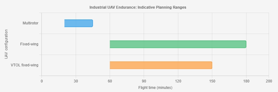
How to read this chart: These broad, indicative flight-time ranges are for early planning, not guaranteed specifications. Actual endurance depends on payload, battery, weather, altitude, and flight profile.
Before choosing an industrial UAV, verify endurance with your intended payload, payload capacity, wind tolerance, operating temperature, IP rating, spare-battery availability, maintenance support, and compliance requirements for your operation.
Keel Mini Quadcopter: A Modular, Long-Endurance Drone for Mapping and Inspection
Keel Mini Quadcopter Modular Design Long Endurance Industrial Drone For Mapping And Inspection
The Keel Mini Quadcopter is designed to make aerial mapping and inspection more efficient without adding unnecessary complexity to field operations. Its modular design allows the aircraft to be configured for different data-collection tasks, while its compact form supports convenient transport and deployment. With long-endurance operation, teams can cover more ground during a flight and spend less time interrupting work to prepare for the next sortie.Built as a professional-grade aerial data solution, the quadcopter can help users capture consistent imagery for site documentation, asset review, and mapping workflows. Its adaptable setup makes it suitable for changing project requirements, from surveying a work area to inspecting infrastructure from the air. By combining flexible equipment options with extended flight capability, the Keel Mini helps crews gather useful information efficiently and make better-informed decisions in the field.
Conclusion
This article explains how Industrial Uavs are defined and classified in China, from compact aircraft designed for close-range inspection to larger platforms built for mapping, transport, or extended operations. It outlines the main factors that help buyers assess performance, including payload capacity, flight time, stability, data quality, ease of operation, and suitability for demanding environments. Different aircraft configurations are compared by their strengths and typical use cases, helping readers understand why no single platform is best for every task.The overview also considers applications across industries such as agriculture, infrastructure, energy, construction, and environmental monitoring. Before choosing a system, buyers should clarify their operational goals, required sensors, working conditions, maintenance needs, training requirements, and total ownership costs. Matching these practical considerations to the aircraft’s capabilities can help organizations select a reliable solution that supports safe, efficient, and consistent work.
About Us
We turn drones from tools into infrastructure, enabling the global low altitude economy with engineering rigor and compliance.To become the core infrastructure provider for the global low altitude economy. We will keep integrating 5G, AI and hydrogen energy to drive standardized, intelligent and green aerial operations.
Media Contact
Company Name: UUUFLY AeroTech Corp.
Contact Person: Media Relations
Email: Send Email
Country: China
Website: https://www.viscolift.com/