
Aerial imaging market is witnessing heavy demand due to growing popularity of capturing photographs from an elevated position across various sectors such as Government, Civil Engineering, Agriculture & Forestry, Military & Defense, etc. Helicopters, rockets, balloons, fixed-wing aircraft, and stand-alone telescoping are some of the commonly used platforms used in aerial imaging. Technological evolutions and growing demand across various application areas such as insurance, energy, etc. is expected to propel the aerial imaging industry demand over the coming years. According to Global Market Insights, Inc., “Aerial Imaging Market size is projected to surpass USD 2.5 billion by 2022.”
Aerial imaging technology is preferably used for various ground based commercial applications. Military application is projected to surpass USD 200 million in the coming five years. Aerial imaging industry is witnessing a substantial growth, due to evolving technology developments in agriculture and insurance sector. For instance, farmers are adopting the aerial imaging technique for monitoring crop diseases, whereas on other hand insurance sector is utilizing this technology to settle down claims in the estimation of damages caused by natural calamities such as hurricanes and floods.
Request for a sample of this research report @ https://www.fractovia.org/request-sample/268
Demographic mapping, road planning, optimum land-use calculations, climate change, etc. are key factors influencing the aerial imaging market size in the civil engineering applications. Moreover, the increasing adoption of aerial imaging technology in other areas including disaster reduction & prevention, engineering & land-use planning, archaeology, and energy management will further boost the aerial imaging industry share.
Asia Pacific aerial imaging market size by application, 2012-2022 (USD Million)
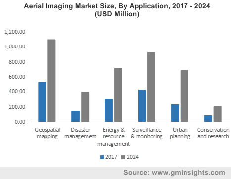
Government sector is projected to account for 29% of the total aerial imaging market share by 2022
Aerial imaging applications mainly comprise government, commercial, military & defense, agriculture & forestry, energy, civil engineering, and insurance. The government sector is predicted to surpass a revenue of USD 750 million by 2022, owing to the increasing usage of this technology for key applications such as urban planning, homeland security, energy management, and monitoring environmental studies. Furthermore, the commercial application will generate lucrative revenue over the coming timeframe, driven by its mounting need for advertising, promotional activities along with its usage to evaluate construction progress.
Make an inquiry for purchasing this report @ https://www.fractovia.org/request-purchase/268
Considering geographical outlook, Asia Pacific aerial imaging market is anticipated to surpass a revenue of USD 400 million by 2022. The growing number of semiconductor companies will be the attributing factor towards the APAC regional growth. In addition, rapid technological development and increasing consumer demands will further influence the regional market share over the coming years.
North America aerial imaging industry size is expected to dominate the global market share over the coming years, owing to the huge investment in R&D along with rising advancement in the telecommunication sector. The mounting number of PAMS and UAVs will increase the demand for aerial imaging elements over the coming years. The Unmanned Aerial Vehicle market is estimated to propel the aerial imaging industry over the coming years, owing to the increasing significance of UAV for the military applications such as strike missions, combat search & rescue (CSAR) operations, suppression of enemy air defense (SEAD).
Aero-Metric Inc., Eagle Aerial Solutions, Google, Eagle View Technologies, Landiscor Aerial Information, and Kucera International Inc. are some of the prominent industry players in aerial imaging market.
Browse key industry insights spread across 80 Pages with 23 market data tables & 22 figures from the report Aerial Imaging Market in detail along with the table of contents:
https://www.fractovia.org/news/industry-research-report/aerial-imaging-market
Global Market Insights has segmented the aerial imaging industry on the basis of application and region:
Aerial Imaging Industry Application Analysis (Revenue, USD Million, 2012 – 2022)
- Government
- Commercial
- Civil Engineering
- Military & Defense
- Forestry & Agriculture
- Energy
- Insurance
Aerial Imaging Industry Regional Analysis (Revenue, USD Million, 2012 – 2022)
- North America
- Europe
- Asia Pacific
- Latin America
- MEA
Browse Related Reports:
- Unmanned Aerial Vehicles (UAV)/Commercial Drone Market Size By Product (Rotary Blade, Fixed Wing, Nano Drone, Hybrid), By Application (Government, Media & Entertainment, Agriculture, Energy), Industry Outlook Report, Regional Analysis, Application Development, Price Trends, Competitive Market Share & Forecast, 2016 – 2023
About Fractovia.org
Fractovia.org is one of India’s leading in-house and free news total admin portal. It is fully automated, and operates on a constant premise, interfacing with news sites and offering redesigned breaking features to readers all across the globe. Our mission is to offer individuals opportunities for connections with news writers and distributors which they can pursue. We operate by mapping articles pertaining to breaking news, constantly and progressively, against a pre-determined word-based theme, offering important connections to readers and clients, as well as distributers.
Media Contact
Company Name: Fractovia.org
Contact Person: Arun Hegde
Email: sales@fractovia.org
Phone: 1 302-846-7766
Address:29L Atlantic Avenue, Suite L 105
City: Ocean View
State: Delaware
Country: United States
Website: https://www.fractovia.org/news/industry-research-report/aerial-imaging-market