
Sheridan, Wyoming, USA – November 10, 2026
When you look at China’s surveying drone scene, you’ve got the big names like DJI, JOUAV, MMC, and Foxtech—they’re pretty established. These drones handle a whole range of mapping tasks, from quick field surveys to longer missions covering large areas. But honestly, a surveying drone isn’t just about the aircraft itself. The camera quality, positioning accuracy, flight planning, and how you process the data all play a huge role in the final output. It’s the whole package that matters.Think about it – on a typical construction site, you might need quick orthomosaic images or repeatable measurements without a lot of fuss. But if you’re in mining or infrastructure, you’d probably care more about endurance, terrain awareness, or having specialized payload options. DJI is pretty well-known for their all-in-one flight and imaging ecosystem, while JOUAV and MMC offer platforms geared toward pro and industrial use. And Foxtech? They supply drone platforms and components too. Honestly, you can’t just look at the brand and decide which aircraft is the best. Different models have different capabilities, so the company name alone doesn’t tell you much.You know, when you’re picking a drone, the little details really do count. Don’t just look at the flashy specs—compare what sensors it supports, whether you’d need RTK or PPK, how long you can actually fly in real conditions, the environment it can handle, the training you might need, and what kind of after-sales support you’d get. And hey, make sure the whole system—aircraft and software—actually fits how you work and what your local rules require. I’ve seen drones that look incredible on paper, but then you get out in the field and it’s a whole different story. That’s why this guide doesn’t just slap a ‘top’ label on any brand; it walks you through what each notable Chinese manufacturer is really good at and what practical things you should think about before dropping your cash. So, picking the right tool really comes down to a few things – the area you’re surveying, how accurate you need to be, what you can spend, and how comfortable your team is with the tech. And here’s the thing: even a great platform can let you down if you don’t pay attention to how the data flows through it.
 Understanding Surveying Drones and Their Core Capabilities
A surveying drone turns an aerial flight into measured, georeferenced information. Its camera or laser sensor records overlapping images or surface points for mapping, inspection, and volume estimates. Positioning systems, flight planning, and onboard timing help align those observations with real coordinates. Ground control and careful checks still matter. Without them, a clean-looking map can hide a shift at a road edge or stockpile boundary. Small details matter. Payload, endurance, wind tolerance, and processing software determine whether a drone fits a quarry, construction site, or farmland. Results also depend on operator skill and site conditions, not the aircraft alone.When comparing manufacturers in China, examine the complete workflow rather than headline camera resolution. Ask for sample datasets, stated accuracy conditions, sensor calibration procedures, and clear support for data export. A useful test is a familiar site with known measurements. Fly it, process it, and compare the output against trusted ground checks. This reveals gaps in calibration or software that a brochure may not show. No system is perfect. Battery swaps, weak connectivity, dust, and uneven lighting can interrupt fieldwork, so practical service and training deserve attention. Manufacturers that explain limitations plainly are easier to assess than those promising universal precision.
How to Evaluate Surveying Drone Manufacturers
A surveying drone manufacturer should be judged by how well its aircraft fits the work, not by a long specification sheet. For open land, a camera with reliable positioning may be enough; steep slopes or dense vegetation can demand different sensors and flight planning. Check whether the manufacturer explains achievable accuracy, flight endurance under a realistic payload, and performance in wind. Ask for sample survey files, not only polished maps. Numbers are not enough.A practical evaluation includes the complete workflow. Can the team explain calibration, ground control, coordinate settings, and data processing in plain language? Request a demonstration over a site similar to yours, then compare the delivered measurements with trusted control points. Ask how replacement parts, software updates, training, and technical support are handled after purchase. A fast reply before a sale means little if field support disappears later. Look closely at service terms.Also inspect the details people tend to skip: battery cycle life, sensor mounting stability, file compatibility, and the time needed to produce usable outputs. A low purchase price can become expensive when each survey requires extra processing or repeat flights. Some manufacturers may not provide independent test results, and that deserves a direct question. No single evaluation fits every project; even a capable system can disappoint when terrain, weather, or operator skill is overlooked.
How to Evaluate Surveying Drone Manufacturers
Suggested evaluation weights for comparing manufacturers; these are planning guidelines, not market survey results.
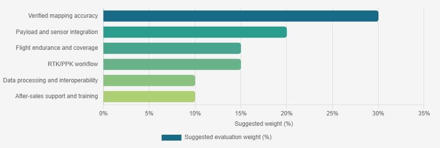
Prioritize independently verified mapping accuracy, then assess sensor compatibility, operational coverage, positioning workflows, data interoperability, and support. Request test results and documentation for each criterion before making a purchasing decision.
Leading Surveying Drone Manufacturers in China
Leading surveying drone manufacturers in China serve mapping teams, engineering firms, and land surveyors with aircraft, sensors, and processing tools. Their product ranges often include compact multirotors for tight sites and fixed-wing platforms for larger areas. Useful differences lie in flight stability, payload options, terrain-following performance, and software workflows. A capable supplier should explain camera calibration, ground control requirements, and expected accuracy in plain terms. Ask for test data from conditions similar to your site, not just ideal demonstrations.Tips: Check sample outputs before purchase. Compare image sharpness, point-cloud density, and delivery time. Confirm how the system handles wind, uneven ground, and battery changes. Small details matter.A careful manufacturer also supports operator training, maintenance, and data troubleshooting after delivery. Request a realistic workflow demonstration, from mission planning to a finished orthomosaic or elevation model. Then check whether the exported files fit your existing software. Specifications can look impressive, but they do not guarantee dependable results in the field. I would still verify performance independently; published accuracy figures may depend on survey setup and local conditions. A short site trial can reveal awkward controls or slow processing that a brochure will miss.
Comparing Drone Platforms, Sensors, and Mapping Systems
Choosing among China’s surveying drone manufacturers means comparing complete mapping systems, not just flight time. A stable platform helps maintain consistent image overlap across a sloped quarry or farmland. Payload capacity matters too: the aircraft must safely carry its camera or laser scanner without sacrificing practical endurance. Ask for sample data, calibration records, and clear specifications.
Sensors shape the final map. A high-resolution camera can capture roof edges and road markings, while a LiDAR unit can record ground points beneath light vegetation. RTK or PPK positioning may reduce reliance on ground control, but it does not remove the need to check accuracy. Mapping software should support the required coordinate system and export formats. Test a small area before committing to a large survey; results can vary with light, wind, and operator settings. One detail is easy to miss: a polished interface does not guarantee clean data.
Tips: Compare sample maps made under similar conditions. Check edge detail, elevation noise, and processing time. Confirm that sensor calibration and software updates are documented. Keep a few ground checkpoints for independent verification. It takes extra time, but it can reveal a mismatch before the full project.
Surveying Applications Across Key Industries
Surveying drones turn hard-to-reach sites into repeatable measurements. On construction projects, overlapping images can reveal earthwork changes, stockpile volumes, and progress against design plans. Mining teams use the same workflows to inspect benches and estimate material volumes without sending staff across unstable ground. A neat map can still be wrong. Flight overlap, camera calibration, ground control, and weather all affect the result, so field checks remain essential.The applications extend beyond construction and mining. Road and utility crews can document corridors, while farms use aerial imagery to spot uneven crop growth or drainage problems. PwC’s 2016 report, Clarity from above, estimated $127.3 billion in potential annual value from drone-powered solutions worldwide, including $45.2 billion for infrastructure and $32.4 billion for agriculture. These figures describe estimated potential, not surveying-drone sales or guaranteed savings. They do show why buyers comparing Chinese surveying-drone manufacturers should assess more than flight time. Ask whether the system captures dependable data for the actual site, then test its maps against known measurements. Small workflow gaps matter. A missed control point or poor overlap can quietly distort a volume estimate.
Choosing a Chinese Manufacturer for Your Project
Choosing a Chinese manufacturer should begin with the deliverable, not the aircraft brochure. Define your required ground sampling distance, coordinate system, terrain conditions, and accuracy class. Ask for a sample orthomosaic, point cloud, and accuracy report from a comparable project. Check whether the company explains its RTK or PPK workflow, ground control, calibration, and processing steps. A polished demo is not enough. Small details matter.Use independent benchmarks when reviewing claims. The USGS Lidar Base Specification sets a 10-centimeter vertical RMSE limit for Quality Level 2 lidar data; this is a reference for lidar, not a universal drone-survey requirement. ASPRS’s Positional Accuracy Standards call for accuracy to be evaluated with independent checkpoints and reported statistically. Ask the manufacturer to show checkpoint results, not just control-point residuals. Also confirm spare-part availability, software updates, training, and realistic repair times in writing. A low quote can become expensive when a sensor sits idle. Still, even a strong test report cannot guarantee results on your site. Request a small paid pilot over a representative area, then review the raw files and final outputs with your survey team.
What Are the Top Surveying Drone Manufacturers in China? – Choosing a Chinese Manufacturer for Your Project
| Evaluation Dimension | What to Compare | Evidence to Request | Project Considerations |
|---|---|---|---|
| Mapping accuracy | Documented horizontal and vertical accuracy for the complete workflow, including the aircraft, sensor, positioning method, processing software, and control strategy. | Independent test reports, stated test conditions, coordinate reference system details, and results from surveyed checkpoints that were not used as ground control. | RTK or PPK positioning can improve georeferencing, but achievable accuracy depends on the sensor, satellite conditions, calibration, terrain, and processing. Confirm accuracy against your project specification. |
| RGB photogrammetry | Camera resolution, lens characteristics, mechanical or electronic shutter, image overlap settings, and compatibility with common photogrammetry workflows. | Sample imagery, camera specifications, calibration information, and a sample orthomosaic or 3D model produced from a comparable site. | Ground sample distance depends on camera and flight height. Surface texture, lighting, image overlap, and moving objects also affect reconstruction quality. |
| LiDAR payload | Laser scanner and navigation-system options, point-cloud density, scan pattern, boresight calibration, and supported data formats. | Representative classified and unclassified point clouds, calibration records, processing workflow, and accuracy results for similar terrain and vegetation. | Vegetation penetration and ground-point quality vary with canopy, terrain, scan geometry, and system settings. Ask for results from conditions similar to your site. |
| Positioning and control | RTK or PPK support, correction-service compatibility, base-station options, event-marking or camera-trigger synchronization, and coordinate-system handling. | Workflow documentation, supported correction formats, field setup requirements, and guidance on independent checkpoints and ground control. | Verify correction availability and coordinate transformations in the project area. Use independent checkpoints to assess delivered results. |
| Flight time and coverage | Endurance with the intended payload, practical coverage per battery, battery replacement process, and operating limits in expected conditions. | Test data specifying payload, flight profile, wind, temperature, battery reserve, and takeoff conditions. | Advertised endurance is not the same as usable survey time. Payload weight, wind, temperature, altitude, and required safety reserves affect coverage. |
| Mission planning and safety | Terrain-following capability, route planning, obstacle awareness, return-to-home behavior, lost-link procedures, and flight-log access. | Demonstration of the planning software, safety documentation, operating manuals, and a description of fail-safe behavior. | Check that planned operations are suitable for local airspace, site hazards, and applicable aviation rules. Automated functions do not replace operational risk assessment. |
| Data workflow | Supported export formats, processing software options, coordinate-system support, data ownership, and compatibility with the project’s GIS or CAD tools. | Sample deliverables, format lists, processing requirements, licensing terms, and a complete trial workflow from capture through export. | Confirm that deliverables can be opened and independently checked using the tools required by your client or project team. |
| Environmental suitability | Published operating limits for wind, temperature, precipitation, dust, and elevation, as well as storage and transport requirements. | Technical specifications, test conditions, maintenance guidance, and written warranty exclusions. | Use the manufacturer’s stated limits rather than assuming performance from a general product description. Site conditions can affect both safety and survey quality. |
| Support and lifecycle | Training, repair turnaround, spare-parts availability, software updates, warranty coverage, and post-sale technical support. | Written service terms, support response commitments, training scope, spare-parts policy, and warranty details for the destination market. | For overseas projects, confirm who provides local-language support, how equipment is serviced, and whether replacement parts can be delivered within project timelines. |
| Compliance and export readiness | Applicable product documentation, radio-frequency compliance, battery transport documents, customs paperwork, and any market-specific approvals. | Current certificates and declarations applicable to the exact configuration and destination, plus export and shipping documentation. | Requirements differ by destination and product configuration. Verify documents with the relevant authorities, importer, or compliance specialist before purchase. |
How to use this table: Compare manufacturers using evidence for the exact aircraft and payload configuration proposed for your project. Specifications and performance vary by model, operating conditions, and workflow; request a project-relevant demonstration and written test results before making a selection.
Conclusion
Surveying drones combine precise flight control, high-resolution imaging, positioning systems, and mapping software to collect reliable geospatial data. When evaluating manufacturers in China, buyers should consider more than price: examine flight stability, payload compatibility, sensor accuracy, data-processing workflows, technical support, and the manufacturer’s ability to adapt equipment to project requirements. Comparing aircraft platforms, cameras, LiDAR options, positioning technologies, and mapping systems can reveal meaningful differences in efficiency and final data quality.These systems support applications such as construction planning, land measurement, infrastructure inspection, agriculture, and environmental monitoring. The right Surveying Drone depends on the terrain, required level of detail, operating conditions, team experience, and intended deliverables. A careful assessment of product capabilities, service resources, customization options, and long-term operating costs can help organizations select a Chinese manufacturer that fits their project and supports dependable surveying results.
About Us
We turn drones from tools into infrastructure, enabling the global low altitude economy with engineering rigor and compliance.To become the core infrastructure provider for the global low altitude economy. We will keep integrating 5G, AI and hydrogen energy to drive standardized, intelligent and green aerial operations.
Media Contact
Company Name: UUUFLY AeroTech Corp.
Contact Person: Media Relations
Email: Send Email
Country: China
Website: https://www.viscolift.com/